Relying on your smartphone for off-grid navigation is a recipe for disaster; true safety comes from mastering a system that anticipates and thrives on technological failure.
- Digital tools (phones, consumer apps) have critical failure points in cold, wet, or remote UK conditions that physical tools do not.
- Proactive planning, based on specialised maps and mountain-specific weather forecasts, is more crucial than any single piece of gear.
Recommendation: Stop treating your map and compass as a ‘backup’ and start treating them as your primary system, practicing with them before your phone inevitably fails.
There’s a powerful allure to leaving the marked path, to cresting a ridge on a crisp morning and seeing a wild, untrodden landscape unfold before you. For the adventurous UK hiker, this is the ultimate freedom. But I’ve pulled too many people off hillsides, hypothermic and terrified, to romanticise the reality. The common advice is to pack a power bank, tell someone your route, and follow the trail markers. This is fine for a Sunday stroll, but it’s dangerously inadequate for the serious explorer.
The core mistake is treating technology as a reliable safety net. It isn’t. The real danger isn’t the weather or the terrain; it’s a misplaced faith in tools that were never designed for the harsh, unpredictable environment of the British fells and moors. Your phone, the cairn markers you spot, even popular mapping apps—they all have critical, predictable points of failure. The feeling of dread when your screen goes black in a freezing mist is something no hiker should ever experience.
But what if the key to off-grid safety wasn’t about having better backups, but about adopting a completely different mindset? This guide is built on a single principle learned over years in mountain rescue: you must master a system of deliberate failure analysis. It’s about understanding precisely *why* and *when* each tool will fail you, so you can seamlessly switch to a proven method long before disaster strikes. We will deconstruct the common myths, build your confidence with a physical OS map, and teach you the strategic thinking that turns a potentially deadly situation into a manageable challenge.
This article provides a structured approach to building that bulletproof navigation system. From debunking trail myths to mastering extreme weather techniques, each section builds upon the last to create a complete framework for off-grid safety.
Summary: A Veteran’s Framework for Off-Grid Navigation Safety
- Why Relying on Cairn Markers Leads You Off the Safe Path?
- How to Read a Physical OS Map When GPS Fails Completely?
- Dedicated GPS Devices vs Smartphone Apps: Which Saves Your Life in a Whiteout?
- The Smartphone Battery Error That Leaves Hikers Stranded on the Moors
- In What Order Should You Tackle High Ridges to Avoid Afternoon Storms?
- Why Google Maps Fails British Drivers on Unpaved Rural Roads?
- The Weather Forecasting Error That Traps Hikers on the Cairngorms
- Hiking the Rugged Patagonian Andes: Surviving 100mph Winds and Freezing Nights
Why Relying on Cairn Markers Leads You Off the Safe Path?
On an open fellside with visibility closing in, a small pile of rocks can seem like a godsend. But this is the first and most dangerous trap for the aspiring off-grid hiker. Cairns—man-made piles of stones—are notoriously unreliable. The core problem is that you can rarely distinguish between an official, purposefully placed marker and a well-meaning but dangerously misleading pile left by another walker. These unofficial cairns can lead you into bogs, towards cliff edges, or simply miles off your intended route. As the experts at Bearfoot Theory warn in their trail safety guide:
A single, false cairn in the wrong spot could cause hikers to miss the trail, with potentially catastrophic results.
– Bearfoot Theory, Rock Cairns & Trail Safety Guide
Treating every cairn as a definitive guide is a gamble. They are not part of a regulated system. Worse, the proliferation of recreational cairns damages fragile ecosystems and can lead to a 15% increase in localized erosion as people disturb soil and vegetation to build them. True navigation means relying on verifiable data from your map, not on ambiguous signals left in the landscape. While official cairns in some national parks are maintained, you cannot afford to make that assumption in the wild. Your safety depends on being able to navigate with or without them.
Official cairns are generally uniform, stable, and placed at critical junctions. In contrast, unofficial ones are often precarious and randomly located. If in doubt, ignore it and trust your map and compass. The skill is not in finding cairns, but in not needing them in the first place.
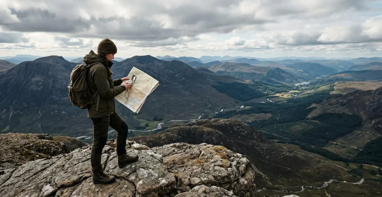
How to Read a Physical OS Map When GPS Fails Completely?
This is the bedrock skill. When every battery is dead and every screen is dark, the paper Ordnance Survey (OS) map and a quality compass are your lifeline. This isn’t nostalgia; it’s about mastering an analogue system that is immune to weather, battery life, and satellite availability. The first step is to orient your map. Place the compass flat on the map and rotate the map until the north-south lines on the map (the grid lines) are parallel with the compass needle pointing north. The map now represents the ground around you.
The real art is reading the contour lines. These thin brown lines are the secret to understanding the shape of the land. When they are close together, the ground is steep. When they are far apart, it’s gentle or flat. A series of concentric circles indicates a summit, while V-shapes pointing uphill denote a re-entrant or gully. This allows you to ‘see’ the landscape in 3D, identifying ridges to follow and valleys to avoid without ever looking up from the map. It’s how you can find your position even in a total whiteout through a technique called triangulation, by taking bearings on visible features.
The illustration below shows the fundamental relationship between your tools and the terrain they represent. This is the core of reliable, self-sufficient navigation.
With the map oriented, you can take a bearing from your map to your destination and follow it on your compass. More importantly, you can use it to verify your location. By taking bearings to two or three known features in the landscape (a peak, a lake, a radio mast) and plotting them on the map, your precise location is where the lines intersect. This is a non-negotiable skill.
Dedicated GPS Devices vs Smartphone Apps: Which Saves Your Life in a Whiteout?
The debate between a dedicated GPS unit and a smartphone app is not about features; it’s about reliability under duress. From a mountain rescue perspective, the answer is unequivocal: a dedicated GPS is a tool, while a smartphone is a liability masquerading as one. The critical differences emerge when conditions deteriorate—precisely when you need navigation the most. A whiteout on a high ridge is no place to discover your touchscreen doesn’t work with gloves or that the screen is unresponsive because it’s wet.
Dedicated GPS devices are built for one purpose: to function in hostile environments. They feature physical buttons that can be operated with thick gloves, are waterproofed to a high standard, and use battery types (like AA or NiMH) that perform far better in the cold than the lithium-ion batteries in phones. They acquire satellite locks faster and more reliably in deep valleys or under heavy tree cover. A smartphone’s A-GPS relies on cell tower assistance, which is often non-existent where you need it most. The following comparison highlights the critical failure points of relying on a phone.
This data, based on a comprehensive comparison of emergency navigation gear, shows a clear winner when your life is on the line.
| Feature | Dedicated GPS | Smartphone |
|---|---|---|
| Battery Performance in Cold | Functions below 0°C with AA/NiMH batteries | Shuts down below 0°C (lithium-ion) |
| Satellite Lock Speed | Fast TTFF with multi-constellation support | Slower A-GPS, struggles in canyons |
| Interface in Emergency | Physical buttons work with gloves/wet hands | Touchscreen fails when wet/cold |
| Reliability | 3-meter accuracy civilian standard | Variable accuracy, depends on cell signal |
| Map Storage | Pre-loaded topographical maps | Requires downloads, may fail offline |
While a dedicated GPS is superior, it is still a piece of technology that can fail. As OffGrid Survival wisely notes, it is never the final layer of your safety system. The ultimate backup remains analogue. This is why, even if you carry a GPS, you are not exempt from mastering your map and compass.
The Smartphone Battery Error That Leaves Hikers Stranded on the Moors
The single most common point of failure I’ve encountered in rescues is a dead smartphone. Hikers venture onto the moors, relying on an app for navigation, only to find their battery plummet from 50% to zero in a matter of minutes as the temperature drops. This isn’t a defect; it’s the fundamental chemistry of the batteries used in consumer electronics. As a critical study on device reliability confirms, lithium-ion batteries in phones can shut down below 0°C. On a windswept British hillside, the wind chill can bring the device’s internal temperature to that point even when the air temperature is several degrees warmer.
This is a predictable failure point. Relying on a power bank is not a complete solution, as many of them use the same temperature-sensitive lithium-ion chemistry. The phone must be treated as a fair-weather convenience, not an all-conditions lifeline. If you do carry one for emergencies or photos, its power must be guarded with military discipline. This means it stays off and insulated deep inside your pack, not in an exposed pocket. Every moment the screen is on, every background app that refreshes, every time it searches for a non-existent signal, it is draining the one resource you might need to call for help.
Preserving that power isn’t just about carrying a backup; it’s a systematic process of minimising drain from the moment you leave the car. Following a strict protocol can dramatically extend your phone’s availability in an emergency.
Action Plan: Smartphone Power Preservation Audit
- Power Mode: Switch to Airplane Mode and Low Power Mode immediately at the trailhead. This stops the constant, draining search for a cell signal.
- Map Preparation: Ensure all topographical maps for your entire route area are downloaded for offline use *before* you leave home. Never rely on streaming map data.
- Insulation: Keep the phone and any power bank close to your body in an internal pocket. Your body heat is the best defence against the cold.
- Background Processes: Manually turn off all background app refresh, location services (except for the mapping app when in active use), and push notifications.
- Screen Management: Reduce screen brightness to the absolute minimum required and set the auto-lock to the shortest duration (e.g., 30 seconds).
In What Order Should You Tackle High Ridges to Avoid Afternoon Storms?
Advanced navigation is less about finding your position and more about making smart, proactive decisions. One of the most critical is route strategy, especially when tackling exposed high ridges. In the UK’s mountains, weather patterns are often predictable: clear mornings can frequently give way to stormy, electrically-charged afternoons. Getting caught on a summit or a knife-edge ridge when a storm rolls in is a life-threatening error. The key is to plan your route not by distance, but by timing and exposure.
Your goal should always be to tackle the highest, most exposed sections of your route in the morning and be descending by early afternoon. This means analysing your OS map to identify these high-risk areas and structuring your day around them. Look at the contour lines: long, narrow ridges with steep drop-offs on either side are no-go zones in high winds or thunderstorms. Your plan must include pre-determined “decision points” and “bailout routes”. A decision point is a specific location on your map (like a saddle or a path junction) that you must reach by a set time. If you don’t make it, you automatically take your planned bailout route down to safer, lower ground.
This removes guesswork and ego from the equation. The decision is made for you by the clock, preventing the fatal temptation to “push on just a little further”.
Case Study: The Scottish Highlands Decision Point Strategy
During a solo expedition across Scotland’s West Highlands and Cairngorms in 2018, an experienced navigator demonstrated the power of this approach. His plan was built around time-based checkpoints. He knew from mountain weather forecasts that conditions often deteriorated after 1 p.m. Therefore, if he hadn’t reached certain key saddles or summits by 11 a.m., he would not proceed to the next high-exposure section. Instead, he would immediately commit to a pre-planned, safer descent route into a valley, ensuring he was off the high ground well before the afternoon weather patterns hit.
This isn’t about cutting your day short; it’s about ensuring you have a day to cut short. It’s a strategic withdrawal that guarantees you’ll be able to come back and hike another time. The mountain will always be there. Your job is to make sure you will be too.
Why Google Maps Fails British Drivers on Unpaved Rural Roads?
Your off-grid adventure often begins with a drive to a remote trailhead, and this is where the first navigation failure can occur. Relying on consumer apps like Google Maps or Waze to navigate the final few miles on unpaved rural or forestry tracks is a classic mistake. These applications are optimized for tarmac roads and urban environments. Their algorithms will often identify a “track” or an old farm road as the shortest route, without any understanding of its actual condition. This can lead to you being directed down an impassable, washed-out lane, getting your vehicle stuck miles from any help.
The technical reason for this failure lies in data resolution. An OS map is built on highly detailed survey data, showing footpaths, bridleways, and 4×4 tracks with precision. In contrast, analysis shows that consumer maps often use coarse 10-20km grid squares for their base data, averaging out terrain and missing crucial details. They simply do not have the granular information to distinguish a proper road from a pair of ruts in a field that hasn’t been used in years. For accessing trailheads in places like the Peak District or the Scottish Highlands, you must cross-reference your driving route with an OS map.
Before you even set off, a vital step is to conduct pre-trip satellite reconnaissance. Use the satellite view layer on your mapping app to visually inspect the final approach to your planned parking spot. Look for gates, signs of road deterioration, or ‘roads’ that are clearly just overgrown tracks. This simple check can save you hours of frustration and prevent your hiking day from ending before it has even begun. Identify a backup parking spot on a reliable road, even if it means a longer walk-in.
The Weather Forecasting Error That Traps Hikers on the Cairngorms
Checking the weather before a hike is basic. Relying on the generic forecast for the nearest town is a potentially fatal error. Mountain weather operates under its own set of rules, and a forecast that predicts a calm, sunny day in Aviemore can be dangerously misleading for someone heading to the Cairngorm plateau just a few miles away. The most significant factor missed by regional forecasts is orographic lift. As wind is forced up and over a mountain range, the air cools, condenses, and forms clouds, leading to localised rain, snow, or whiteouts on the summit, while the valley below remains clear.
As one expert guide on alpine weather explains, this is a matter of data resolution.
Generic city forecasts use coarse data grids averaging weather over large areas, completely missing mountain effects where orographic lift can create blizzards at summits while valleys remain calm.
– Mountain Weather Services, Alpine Weather Forecasting Guide
For any serious UK hillwalking, you must use a dedicated mountain weather service. The Mountain Weather Information Service (MWIS) and the Met Office’s mountain forecasts are essential resources. They provide predictions for specific mountain areas, detailing likely conditions at different elevations, wind speeds on the summits, and—most critically—the freezing level and wind chill. The ‘feels like’ temperature is far more important for survival than the actual air temperature.
The difference in the level of detail is a matter of life and death, as shown by the resolution and metrics these different services use.
| Forecast Type | Grid Resolution | Mountain Accuracy |
|---|---|---|
| City/Regional Forecast | 10-20km squares | Misses localized summit conditions |
| Mountain Weather Service | 1-2km grids | Predicts orographic effects |
| Temperature Shown | Actual temperature | Nearly useless metric |
| Critical Factor | Wind chill calculation | True survival metric |
Key Takeaways
- Never trust a smartphone as your primary navigation tool; its battery and interface are designed for cities, not mountains.
- Mastering a physical OS map and compass is the only truly failure-proof system for off-grid navigation.
- Strategic planning—based on timing, bailout routes, and mountain-specific weather—is more important than any single piece of gear.
Hiking the Rugged Patagonian Andes: Surviving 100mph Winds and Freezing Nights
While the UK fells have their challenges, looking at how navigation skills are applied in the world’s most extreme environments provides the ultimate lesson in resilience. In places like the Patagonian Andes, where 100mph winds are common and temperatures plummet, navigation becomes an exercise in pure survival. Here, the principles of understanding failure points and reading the environment are not just best practice; they are the only things that keep you alive. When visibility drops to zero in a blizzard, even a GPS can be useless if you can’t see the next 10 feet in front of you.
This is where advanced environmental reading comes into play. You learn to use the terrain itself as a compass. The direction of the prevailing wind, the side of a tree that has moss on it, the angle of the sun—these become your directional indicators. It’s about building a mental map that is constantly updated with sensory input, not just data from a screen. This is the pinnacle of the off-grid mindset.
Case Study: Extreme Weather Navigation with The Survival University
Retired Army Ranger Matt Boger’s advanced navigation course demonstrates these principles under brutal conditions. Trainees are taught to navigate a 4,500-acre ranch with poor visibility. They learn to use the constant, prevailing wind as a directional arrow, allowing them to maintain a consistent bearing without a compass. Simultaneously, they use their topographical maps to identify lee sides of ridges or depressions in the terrain to seek shelter from that same wind’s destructive power, turning a threat into a tool.
In these conditions, simply setting up a tent becomes a technical challenge. It must be angled perfectly into the wind to avoid being shredded. Low rock walls may need to be built as windbreaks. Every piece of gear must be secured with multiple anchor points. This level of preparation and skill shows that true mastery isn’t about having the fanciest gear, but about having the knowledge to survive with the bare minimum when everything else has failed. It’s a mindset that is as applicable on Dartmoor as it is in the Andes.
Ultimately, the journey to becoming a confident off-grid navigator is a journey away from dependency. It’s about systematically replacing technological faith with personal skill, situational awareness, and a deep respect for the power of the natural world. Start by practicing these skills on familiar ground, so when you are truly out in the wild, your actions are second nature. Your safety depends not on the gear in your pack, but on the knowledge in your head.