The key to confidently exploring Europe’s remote villages isn’t just renting the right car; it’s adopting a proactive ‘overlander’s mindset’ that anticipates digital failures and logistical challenges.
- Technology is unreliable: GPS routes you onto impassable tracks and mobile signal disappears in deep valleys, requiring analogue workarounds.
- Driving mechanics matter: Manual cars offer superior control on steep terrain, and specific single-track road etiquette prevents costly rental damage.
Recommendation: Shift from being a tourist who follows a satnav to an explorer who conducts pre-trip reconnaissance and manages resources like fuel with a calculated safety margin.
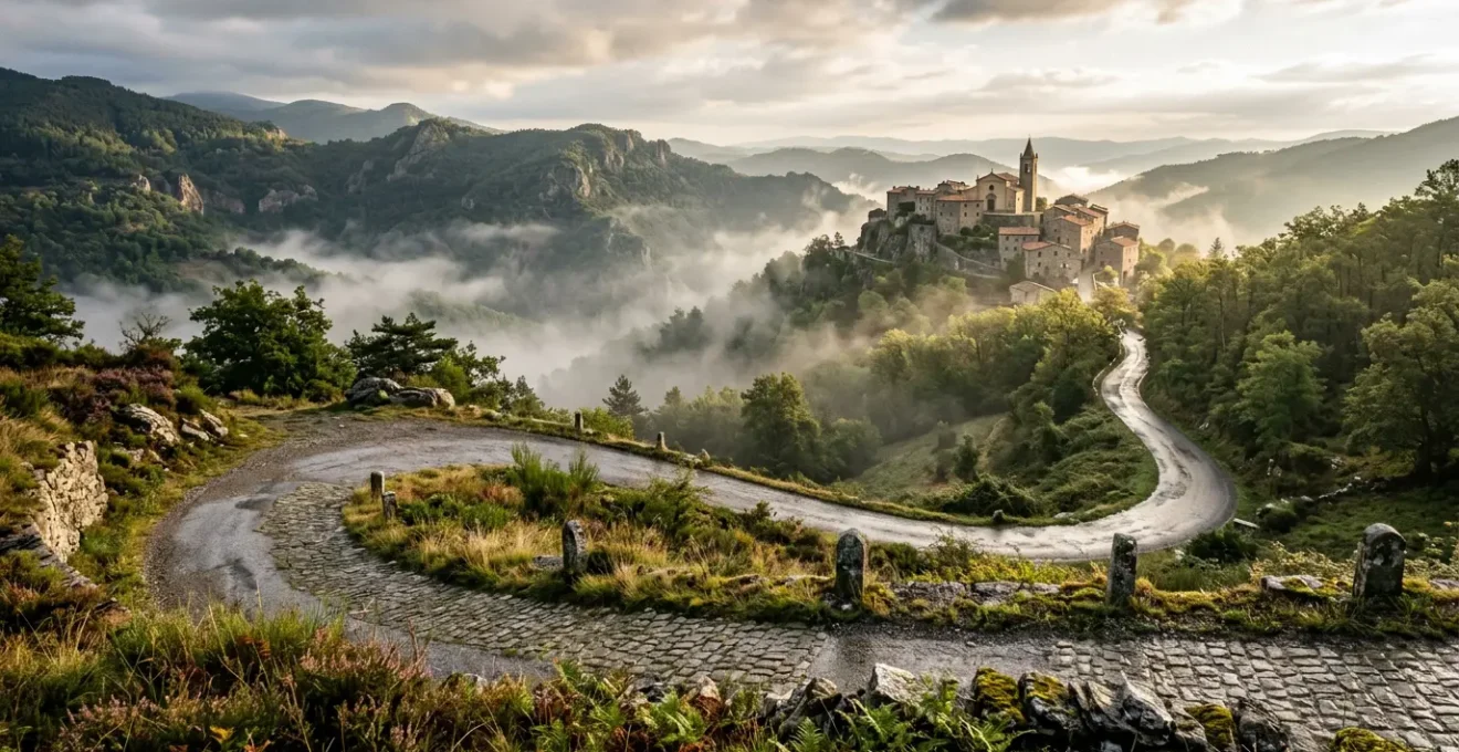
The dream is a powerful one for any culture-seeking driver: leaving the motorway behind, winding through olive groves in rural Spain or vineyards in Italy, and stumbling upon a sun-drenched piazza in a village that time forgot. It’s a vision of authentic Europe, far from the tourist trail. But for many UK drivers, this dream is quickly overshadowed by logistical anxiety. What if the roads become impassable? What if I damage the rental car on a narrow lane? What if I get lost with no phone signal?
The standard advice often feels inadequate. “Rent a small car” and “download offline maps” are starting points, but they don’t prepare you for the reality of deep rural geography. These tips are about damage control, not empowerment. They fail to address the core issue: the mindset we bring from predictable UK roads is the biggest liability when navigating the unmapped corners of the continent. The true challenge isn’t just the narrowness of the roads, but the unreliability of the technology we depend on.
But what if the solution wasn’t just better preparation, but a different philosophy altogether? This guide is built on an overlander’s approach. It’s a system for turning uncertainty into adventure by mastering the real-world challenges of rural exploration. We will deconstruct the common points of failure—from lost mobile signal to misleading GPS—and provide the strategies to overcome them. We will cover the mechanics of driving safely on extreme terrain and the human skills needed to communicate when your translator app is useless. This isn’t just about avoiding disaster; it’s about building the confidence to seek out those hidden gems, safely and without stress.
This article provides a structured approach to developing that confidence. Each section tackles a specific challenge, offering the strategic thinking and practical skills needed to transform your European road trip from a source of anxiety into a true journey of discovery.
Contents: A Strategic Guide to Rural European Driving
- Why Deep Valley Villages Completely Block Your Mobile Roaming Signal?
- How to Communicate With Elderly Locals When Digital Translation Fails?
- Automatic vs Manual Rental Cars: Which Is Essential for Steep Rural Geography?
- The Single-Track Road Mistake That Causes £1,000 of Rental Damage
- When Should You Refuel Your Car to Avoid Being Stranded in the Countryside?
- Why Google Maps Fails British Drivers on Unpaved Rural Roads?
- Sorrento vs Salerno: Which Base Offers Better Access to the Coastline?
- Conquering the Amalfi Coast: Why Renting a Car Will Ruin Your Italian Holiday?
Why Deep Valley Villages Completely Block Your Mobile Roaming Signal?
The first sign that you’ve truly left the beaten path is often the sudden disappearance of your phone’s signal bars. In the deep, V-shaped valleys of regions like Italy’s Apennines or Spain’s Picos de Europa, this isn’t a glitch; it’s a physical certainty. Mobile signals travel in relatively straight lines, and the sheer mass of rock and earth forming the valley walls creates a “terrain shadow,” effectively blocking the signal from distant masts. While urbanites are used to near-constant connectivity, an overlanding mindset means accepting and planning for these digital blind spots.
The problem is more widespread than many think. Even in a highly developed continent, the International Telecommunication Union’s 2024 report notes that 2% of Europe’s rural population lacks mobile coverage. In mountainous regions, that percentage is functionally much higher for a traveller moving through valleys. Relying on your UK provider’s roaming to work for navigation or emergency calls is a high-risk gamble. When the screen says “No Service,” you are on your own unless you have a backup plan.
However, “No Service” on your primary network doesn’t always mean there are no networks at all. Sometimes, a local provider has a weak signal that your phone, set to automatic, won’t connect to. Forcing a manual network search can be a crucial first step before declaring yourself offline. This simple procedure forces your phone to show all available networks, not just its preferred partners.
- Go to your phone’s network settings (typically under ‘Cellular’ or ‘Network & Internet’).
- Turn off the ‘Automatic’ network selection toggle.
- Wait for 30-60 seconds as your phone scans for all local carriers.
- A list of networks will appear. Tap on a different provider from your current one.
- If it fails to connect, try the next one on the list. A successful connection to a new network can restore basic call functions, even if data roaming remains patchy.
How to Communicate With Elderly Locals When Digital Translation Fails?
You’re in a digital blind spot, a paper map has led you astray, and you need directions. You pull over where an elderly man sits outside his house. Your translation app is offline. This is a classic rural explorer’s scenario where technology fails and human skills become paramount. In many remote villages, the older generation speaks only the local dialect and has little experience with smartphones. Holding a dead screen up to them will only create confusion.
The solution is to build an analogue bridge—a non-digital communication toolkit. Seasoned travellers and even healthcare professionals working with diverse elderly populations rely on simple, universal methods. The key is to remove language entirely and communicate through shared, basic concepts. This means having tools ready before you need them.
A simple, effective tool is a set of laminated picture cards. These can be DIY or downloaded, featuring clear icons for fundamental needs: a petrol pump, a fork and knife, a bed, a telephone, a wrench for mechanical trouble, or a simple question mark. When you need help, you can simply point to the relevant icon. This gesture is universal and immediately clarifies your need without a single shared word.
This approach transforms a moment of potential panic into a simple, human interaction. Gestures are your next most powerful tool. Simple charades for “eat” or “sleep” are universally understood. A questioning look while pointing down two diverging paths is the oldest form of asking for directions. Combining a picture card (e.g., the petrol pump icon) with a questioning gesture creates a clear, concise request: “Where is the fuel station?” This simple, low-tech system is infinitely more reliable than a dead app.
Automatic vs Manual Rental Cars: Which Is Essential for Steep Rural Geography?
The choice of rental car transmission is often seen as a matter of personal comfort, especially for UK drivers accustomed to automatics. In a city or on the motorway, that’s true. But in steep, mountainous terrain, it becomes a critical safety and vehicle preservation issue. The default choice of an automatic can be a significant disadvantage when navigating the tight hairpins and dramatic descents of rural Italy or Spain.
The core issue is control, specifically during long, steep descents. An automatic transmission is designed to shift up for fuel efficiency, meaning you rely almost entirely on your brakes to control speed. On a 10km mountain descent, this can lead to the brakes overheating, a phenomenon known as brake fade. This is a dangerous situation where the brakes become less effective, increasing your stopping distance dramatically. A manual car, however, gives you the powerful tool of engine braking.
By shifting into a lower gear (second or third), you use the engine’s compression to keep the car at a slow, controlled speed without ever touching the brake pedal. This keeps the brakes cool and ready for when you actually need them. As one experienced driver on a travel forum wisely noted, this mechanical advantage is not just a preference but a functional superiority in challenging conditions.
I’ve done a lot of mountain driving and while it is possible to manually downshift an auto to lighten the load on the brakes, a manual is more effective in that situation.
– Experienced driver on Rick Steves Forum, Rick Steves Travel Forum
Furthermore, a manual gearbox offers more precise control when starting on a steep incline or navigating a tight, uphill hairpin where you need to maintain momentum. While modern automatics are improving, a traditional manual provides an unfiltered connection between the driver, the engine, and the road that is invaluable in demanding geography. If you are not confident with a manual, practice before your trip. The control it affords is a cornerstone of safe mountain driving.
The Single-Track Road Mistake That Causes £1,000 of Rental Damage
Nothing says “deep rural Europe” quite like a single-track road, often flanked by ancient stone walls or a steep, unforgiving drop. For a UK driver, these roads feel familiar, yet the context is different and the risks are higher. The single most expensive mistake drivers make is a failure of verge-assessment. Misjudging the stability of the soft edge of the road to let another car pass can easily result in a wheel sinking into a hidden ditch, causing thousands in underbody and suspension damage that is rarely covered by standard rental insurance.
These roads are a game of chicken played in slow motion, and winning requires a specific protocol rooted in observation and communication. The primary rule is to always be looking for your next passing place. Before you enter a narrow stretch, your eyes should already be on the next available pull-in. This is not a place for optimistic driving; it’s for defensive, strategic positioning. It’s about anticipating, not reacting.
The unwritten rules are simple but crucial. Priority is generally given to the vehicle going uphill, as reversing down a steep, narrow lane is significantly more difficult and dangerous. When you pull into a passing place, a quick flash of your headlights signals to the oncoming driver that they are clear to proceed. A friendly wave is the universal sign-off. If a section is exceptionally tight, pre-emptively folding in your wing mirrors can be the difference between a smooth pass and a shattered piece of plastic.
Your Action Plan: Single-Track Road Protocol
- Identify the next passing place before you commit to a narrow section.
- Visually assess verge stability; never pull onto grass or soft-looking ground that could hide a ditch.
- Proactively fold mirrors before entering tight gaps between walls or buildings.
- Yield to uphill traffic; if you are going downhill, you are the one who should reverse to the last passing place.
- Use a headlight flash to signal to the other driver that they can proceed once you are safely pulled over.
When Should You Refuel Your Car to Avoid Being Stranded in the Countryside?
In urban driving, the fuel gauge is a casual suggestion. In the remote countryside, it’s a ticking clock. The common “half-tank rule” is a good start, but it’s not sophisticated enough for true rural exploration. Fuel stations can be 50 miles apart, some close on Sundays or for a long lunch, and many older, unmanned pumps may not accept your UK bank cards, despite high rural internet penetration. Data from Eurostat shows that while 90.5% of EU rural households have internet access, this doesn’t guarantee that a specific village’s 20-year-old payment terminal is compatible with foreign cards.
The overlanding mindset requires a more robust system. Instead of reacting to the gauge, you must proactively manage your resource horizon. This means never entering a remote area without a clear plan for refueling. The most effective technique is calculating your ‘Point of No Return’. It’s a simple but powerful mental exercise to perform before you leave a major town.
Here’s how it works: first, use your map to identify the next confirmed, 24-hour fuel station on your route or in the region you plan to explore. Let’s say it’s 60 miles away. Now, apply a safety multiplier of 1.5 to account for potential detours, getting lost, steep terrain that increases consumption, and the possibility that the station might be unexpectedly closed. That gives you a required range of 90 miles (60 x 1.5). Now, look at your car’s fuel range. If it shows less than 90 miles, you refuel now, no exceptions. If it shows more, you are safe to proceed.
This simple calculation removes all guesswork and anxiety. It replaces a vague hope of finding a station with a concrete, data-driven decision. It’s the difference between being a tourist and being an explorer. Carrying a small amount of cash in local currency is also a wise backup for older pumps that may not take cards at all. Never assume a rural station will be open or that your card will work; assume it won’t, and plan accordingly.
Why Google Maps Fails British Drivers on Unpaved Rural Roads?
We are conditioned to trust our GPS implicitly. In 99% of situations, it’s a remarkable tool. But in that 1%—on the fringes of rural Europe—that trust can become a serious liability. The primary failure of apps like Google Maps is their core algorithm: they are programmed to find the shortest or fastest route, not necessarily the most viable one. For an algorithm, an unpaved farm track or a crumbling goat path can look like a clever shortcut. For a driver in a rental Fiat 500, it’s a trap.
These apps often lack granular data on road surface quality. The infamous Italian “strade bianche” (white roads) can range from well-maintained gravel superhighways to potholed tracks suitable only for a tractor. Google Maps often can’t tell the difference, leading unsuspecting drivers onto routes that risk tyre, suspension, and underbody damage. This is where the overlanding principle of route reconnaissance becomes essential. Never blindly follow a digital route into an unknown rural area.
The most powerful reconnaissance tool at your disposal is, ironically, another Google product: Street View. Before your trip, from the comfort of your home, you can vet your proposed route. Don’t just look at the line on the map; drop the little ‘pegman’ icon onto the road at key junctions and decision points. This allows you to visually inspect the road ahead. Is it paved? How wide is it? Are there stone walls right at the edge? Is that ‘road’ actually someone’s driveway? One traveller in Scotland noted their car’s built-in, proprietary satnav was more reliable than their phone, precisely because it used map data (like TomTom or HERE) that often has better classifications for road types than the crowd-sourced data Google sometimes relies on.
This pre-trip audit takes minutes but can save you hours of stress and potentially hundreds of pounds in damages. It allows you to spot and bypass problematic sections, opting for a slightly longer but safer paved route. Trusting the blue line on the screen is a passive act; vetting the route yourself is an active, strategic one.
Sorrento vs Salerno: Which Base Offers Better Access to the Coastline?
Nowhere are these principles of strategic positioning more critical than in Italy’s most famous—and challenging—landscapes. Many UK drivers dream of exploring the Amalfi Coast, and the default choice for a base is often the famous town of Sorrento. This is a strategic error that can lock you into a bubble of extreme traffic, exorbitant parking costs, and immense frustration, severely limiting your ability to explore.
Sorrento is on the wrong side of the peninsula for efficient exploration. To even begin the Amalfi Drive, you must first navigate a busy, winding road just to get to the starting point. An overlander thinks about “escape velocity”—how quickly can I get from my base to open, explorable roads? From Sorrento, the escape velocity is virtually zero. You are in the tourist traffic jam from the moment you start the engine.
A far more strategic base is the city of Salerno, located at the eastern end of the coast. While less famous, it is a driver’s paradise in comparison. It offers direct access to the A3 autostrada, allowing you to easily escape north to Pompeii or south to the spectacular and much less crowded Cilento National Park. When you do want to tackle the Amalfi Coast, you can do so from a logical starting point, and crucially, you have a manageable place to return to. Parking is more available and affordable, and the overall traffic is that of a normal Italian city, not a hyper-concentrated tourist trap.
A comparative analysis of the two locations as a driving base makes the choice clear for anyone prioritizing exploration over a specific hotel view. The logistical advantages of Salerno far outweigh the postcard fame of Sorrento for a self-driving traveller.
| Factor | Sorrento | Salerno |
|---|---|---|
| Traffic Density | Very high, tourist-focused | Moderate, more manageable |
| Parking Availability | Extremely limited and expensive | More available, affordable |
| Highway Access | Difficult, must navigate busy coast road | Direct access to A3 autostrada |
| Escape Velocity | 60+ minutes to clear traffic | 15 minutes to open roads |
| Access to Remote Areas | Locked into Amalfi tourist bubble | Easy access to Cilento, inland regions |
Key Takeaways
- Assume technology will fail; have analogue backups for navigation and communication.
- Choose your vehicle based on the terrain’s demands; a manual offers superior control in mountains.
- Manage resources like fuel proactively using a calculated safety margin, not just by reacting to the gauge.
Conquering the Amalfi Coast: Why Renting a Car Will Ruin Your Italian Holiday?
Having established the strategic advantage of Salerno, we must now address the ultimate question: should you drive the Amalfi Coast at all? For the culture-seeking driver, the answer is a hard, strategic “no.” The very act of driving this iconic stretch of road is the thing that will prevent you from enjoying it. This isn’t a failure of driving skill; it’s a simple, unchangeable equation of logistics, cost, and stress.
The road itself (the SS163) is an engineering marvel, but it is functionally a 40km-long traffic jam for six months of the year. You will spend the majority of your time staring at the bumper of the bus in front of you, not the breathtaking views. When you do arrive in a town like Positano or Amalfi, the next challenge begins: parking. Parking is exceptionally scarce and astronomically expensive, with typical costs running to €50-80 for a day, if you can even find a space. Add to this the constant risk of straying into a ZTL (Limited Traffic Zone), which carries an automatic fine of over €100, and the financial burden becomes immense.
The overlanding mindset is about choosing the right tool for the job. And for exploring the core towns of the Amalfi Coast, a car is the wrong tool. The smart strategy, recommended by seasoned Italy travellers, is a hybrid approach. Use your rental car for what it’s good at: exploring the vast, open, and beautiful inland regions like Basilicata or the Cilento from your base in Salerno. When you want to visit the coastal towns, park the car at your hotel in Salerno and use the excellent, efficient, and scenic public transport.
The ferries that connect Salerno, Amalfi, and Positano offer the best views of the coastline you will ever see—far better than what you can glimpse from the driver’s seat. They are relaxing, relatively inexpensive, and deposit you right in the heart of each town, stress-free. This hybrid strategy allows you to experience the freedom of a road trip and the beauty of the coast, without the misery of trying to combine them. It’s the ultimate application of the overlander’s principle: adapt your strategy to the terrain.
Therefore, before planning your next European road trip, shift your perspective. Stop thinking about merely surviving the drive and start thinking like a strategist. Analyse your route, choose your base wisely, and select the right mode of transport for each specific environment. This is how you unlock the true joy of discovery.