Relying solely on your GPS to reach a remote village isn’t just optimistic—it’s the first link in a chain of preventable failures.
- Digital maps are notoriously unreliable on unpaved, unmaintained, and private rural roads, leading to significant navigational errors.
- Vehicle choice, meticulous preparation, and accurate fuel calculation for off-road conditions are non-negotiable for self-sufficiency.
- True safety lies in redundant communication systems and a pre-planned protocol for handling extreme delays, not just a mobile phone.
Recommendation: Adopt an expedition mindset. Manually verify every route, plan for total self-sufficiency in fuel and repairs, and understand the mechanical limits of your vehicle before you even turn the key.
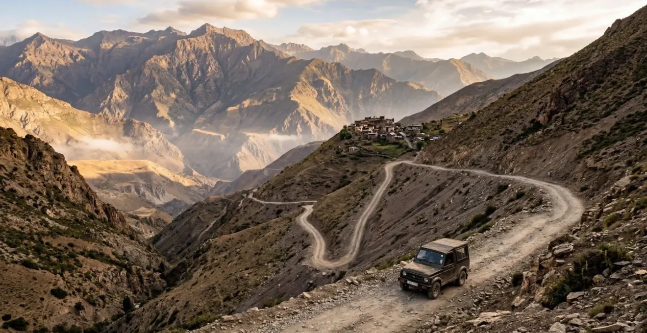
For the adventurous UK driver, the allure of the un-driven path is a powerful call. The dream is to leave the motorway behind, to find those hidden hamlets in the European countryside or beyond, where the rhythm of life is untouched by the frantic pace of the modern world. The journey begins where public transport ends, but the real challenge starts where the tarmac disappears and your mobile phone loses its last bar of signal. This is the last hundred miles—the most critical and most frequently underestimated part of any true exploration.
Common advice will tell you to check your tyres and pack a bottle of water. This is tourist thinking. For the terrain you’re about to enter, it’s dangerously insufficient. When you’re miles from assistance, a simple miscalculation becomes a crisis. The real risks aren’t just a flat tyre; they are navigational black holes, fuel starvation, communication vacuums, and the unforgiving reality of extreme weather. The problem isn’t the lack of a road; it’s the lack of an appropriate mindset.
This guide discards platitudes and focuses on the professional expedition driver’s approach. We’re not just planning a trip; we’re mounting a small, self-sufficient expedition. We’ll dismantle the false security of consumer-grade technology and rebuild a robust strategy based on manual verification, mechanical sympathy, and system redundancy. We will cover the critical failures of standard navigation, how to properly select and prepare your vehicle, the life-or-death decision of communication devices, the art of fuel logistics, and how to survive when things inevitably go wrong. This is about transforming your approach from a hopeful traveller to a competent explorer.
In this guide, we’ll deconstruct the essential components of safe remote travel. Each section builds on the last, creating a comprehensive framework for any driver looking to venture beyond the reach of conventional infrastructure.
Summary : An Expedition Driver’s Framework for Navigating Beyond the Grid
- Why Google Maps Fails British Drivers on Unpaved Rural Roads?
- How to Prepare Your 4×4 Rental for a 100-Mile Off-Grid Journey?
- Satellite Phones or Local SIMs: Which Guarantees Emergency Contact?
- The Fuel Estimation Mistake That Strands 1 in 5 Rural Explorers
- How to Overcome Extreme Weather Delays in Isolated Regions?
- Why Google Maps Underestimates South Island Driving Times by 30%?
- Automatic vs Manual Rental Cars: Which Is Essential for Steep Rural Geography?
- Navigating Rural Geography: Unlocking Europe’s Hidden Villages Safely
Why Google Maps Fails British Drivers on Unpaved Rural Roads?
The primary point of failure for most rural expeditions begins before the engine is even started: an over-reliance on consumer-grade digital maps. For a UK driver accustomed to the dense and well-documented A and B-road network, it’s easy to assume the same level of accuracy applies to the green lanes of the UK or the unpaved tracks of rural Spain. This is a critical error. Google Maps, Waze, and other algorithms are optimized for traffic flow on paved surfaces; they are not designed for off-road viability assessment.
These systems often cannot distinguish between a public byway, a private farm track, or a long-abandoned forestry road. The algorithm sees a line connecting two points and, in its quest for the ‘shortest’ route, will happily direct you onto a path that may be gated, washed out, or requires a vehicle with 3 feet of ground clearance. It has no concept of “passable.” It doesn’t understand the difference between a summer-dry track and a winter mud bog. This digital blindness is a recipe for getting stranded, trespassing, or damaging your vehicle.
The expedition mindset requires you to treat any digital route as a mere suggestion, a hypothesis that must be rigorously tested. This process is called ground-truthing. Before a journey, your primary tool shouldn’t be the routing feature, but the satellite and terrain layers. You must manually trace the proposed route, looking for tell-tale signs of trouble: changes in road colour or width indicating a shift from tarmac to dirt, the sudden appearance of gates, or track sections that vanish into dense tree canopies. This manual analysis is non-negotiable.
The image above isn’t just about looking at a map; it’s about interrogation. You’re cross-referencing the digital line with visual evidence. You’re looking for discrepancies, for the subtle clues the algorithm ignores. This active, manual verification is the first and most important step in taking control back from the machine and ensuring your journey is based on reality, not a flawed digital assumption. The map is a starting point; your eyes and your judgment are the final arbiters.
How to Prepare Your 4×4 Rental for a 100-Mile Off-Grid Journey?
Once you accept that you cannot fully trust the map, the logical conclusion is that you must be able to implicitly trust your vehicle. For a 100-mile off-grid journey, your 4×4 is not just transport; it is your lifeline, your shelter, and your only guaranteed ticket back to civilization. Arriving at a rental agency and simply accepting the keys is an act of blind faith you cannot afford. You must conduct a thorough pre-departure inspection with the same rigour as a pilot’s pre-flight check. This isn’t about checking the fluid levels; it’s about verifying its expedition capability.
The average rental 4×4 is equipped for city streets and occasional gravel, not sustained remote travel. Your inspection must focus on the components that fail under stress. Are the tyres genuine all-terrain (A/T) or just highway-terrain (H/T) tyres that look rugged? Is the spare a full-size, identical wheel, or a temporary “donut” that’s useless 50 miles from the nearest road? You must find and test the jack and tool kit to ensure they are complete and functional for your specific vehicle. Most importantly, you need to engage the 4WD system—high and low range—to confirm it works *before* you need it on a steep, slippery incline.
This self-reliance is paramount because, as experts in remote living know, emergency services are often a theoretical concept. The mindset has to shift from “I can call for help” to “I must be able to get myself out.” This involves checking for properly rated recovery points (not just cosmetic tow hooks), inspecting undercarriage protection, and meticulously documenting any prior damage with your phone’s camera to avoid disputes later. You are not just a customer; you are the acting fleet manager for this one-vehicle expedition.
Your Pre-Departure 4×4 Inspection Protocol
- Tyres and Spare: Check for proper all-terrain tyres (not standard all-season) with adequate tread depth and verify the presence of a full-size spare, not a temporary donut.
- Tools and Recovery: Confirm the jack and tool kit are complete and functional, and verify that recovery points are properly rated and not just cosmetic.
- 4WD System: Test the 4WD engagement system, shifting between 2WD, 4-High, and 4-Low to verify it engages and disengages smoothly.
- Undercarriage and Damage: Inspect undercarriage protection plates for damage or missing components and document any existing vehicle damage with photos before departure.
- Contingency Planning: Acknowledge that in many remote areas there is no government oversight, requiring you to create and be ready to execute your own evacuation plan.
Completing this checklist isn’t just about mechanical security; it’s a mental exercise. It forces you to think through potential failure points and confirm you have the tools and knowledge to address them. This is the essence of building a self-sufficient expedition platform.
Satellite Phones or Local SIMs: Which Guarantees Emergency Contact?
Your meticulously prepared vehicle and verified route are your primary risk mitigation tools. But in remote territory, you must plan for catastrophic failure. If you are immobilized by a mechanical breakdown, a medical emergency, or an impassable obstacle, your ability to communicate your location and status becomes the single most critical factor for survival. Here, the choice between a local SIM card and a dedicated satellite device is not a matter of preference; it’s a matter of understanding operational realities.
A local SIM card is an excellent tool for communication *within* populated areas. It is cheap, effective for data, and allows for easy local contact. However, its usefulness evaporates the moment you leave the reach of cell towers, which is precisely when you are most likely to need emergency help. Relying on a local SIM for off-grid safety is like bringing a water pistol to a firefight. It creates a dangerous illusion of security. True remote communication requires a device that bypasses terrestrial infrastructure entirely.
This is where satellite technology becomes non-negotiable. However, “satellite device” is not a single solution. The choice between a Personal Locator Beacon (PLB), a satellite messenger, or a satellite phone depends on your mission and risk tolerance. A PLB is a last-resort device, a simple button that sends a one-way SOS to global rescue services. A satellite messenger allows for two-way text-based communication and tracking. A satellite phone provides voice communication, but is the most expensive and can be finicky about line-of-sight to the sky. The extreme isolation of places like Point Nemo serves as a stark reminder of the planet’s vastness. As the MIRA Safety Research Team notes in their Analysis of Remote Location Communications:
The closest human beings to Point Nemo are on the International Space Station – that’s how far away it is from human habitation
– MIRA Safety Research Team, Analysis of Remote Location Communications
This single fact underscores the need for a communication system that is entirely independent of terrestrial support. The following table breaks down the options, moving from a simple SOS to full voice capability. For any serious remote expedition, a local SIM is a supplement, never the primary safety line. The real decision is between a messenger and a full satellite phone, balanced against cost and the need for two-way voice.
| Device Type | Best Use Case | Key Limitations | Coverage |
|---|---|---|---|
| Personal Locator Beacon (PLB) | Life-threatening emergencies only | One-way SOS only, no confirmation | Global via satellite |
| Satellite Messenger (Garmin inReach) | Two-way messaging, tracking, SOS | Subscription required, battery life | Global via Iridium network |
| Satellite Phone | Voice calls from anywhere | Line-of-sight required, expensive minutes | Near-global with gaps |
| Local SIM Card | Local communication, data access | No coverage in remote areas | Population centers only |
The Fuel Estimation Mistake That Strands 1 in 5 Rural Explorers
You can have the best-prepared vehicle and a flawless satellite communication plan, but both are useless if you run out of fuel 10 miles from your destination. Fuel logistics are the unglamorous, mathematical core of any successful expedition. The most common and dangerous mistake adventurous drivers make is applying highway driving logic to off-road conditions. Your vehicle’s stated MPG is a fiction in the wilderness. Believing it will strand you.
Off-road driving is a constant battle against resistance. Soft sand, deep mud, rocky terrain, and steep inclines dramatically increase fuel consumption. A vehicle that gets 25 MPG on the motorway might get as little as 10-12 MPG in challenging terrain. Calculating your range based on the dashboard computer is a rookie error. The expedition driver’s method is based on a conservative, modified calculation that accounts for terrain, elevation, and a non-negotiable safety margin. This is crucial in areas where transportation options are severely limited; a US Department of Transportation report highlights that only 36% of rural residents have a choice between multiple transportation services, underscoring the need for total self-sufficiency.
The cardinal rule of expedition fuel planning is this: your halfway point is not at 50% of your fuel tank. It’s at 60%. This “turn-around” or “point of no return” calculation builds in a vital safety buffer. You use 40% of your fuel on the outward leg. If you reach your destination, you have 60% remaining for the return journey, which accounts for unforeseen detours, difficult sections you need to re-attempt, or the need to assist another traveller. You always plan to arrive back at your starting point (or the next known fuel stop) with a minimum of 25% fuel in reserve.
This requires a disciplined approach. You must know your vehicle’s tank capacity, calculate a baseline consumption, and then apply brutal modifiers. For example, you might decrease your expected range by 25% for sustained gravel roads and by as much as 40% for soft sand. This isn’t pessimism; it’s professionalism. It’s the difference between a successful adventure and becoming a cautionary tale—another explorer stranded by a simple, avoidable calculation error.
How to Overcome Extreme Weather Delays in Isolated Regions?
The final, uncontrollable variable in any expedition is weather. In remote regions, a sudden storm, flash flood, or blizzard isn’t an inconvenience; it’s a potentially life-threatening event that can trap you for days. Your planning must extend beyond getting to your destination to include a protocol for surviving an extended, unplanned stop. When you are isolated, your vehicle ceases to be transport and becomes your survival shelter. The ability to wait out a storm safely is as crucial as the ability to navigate.
The history of isolated communities is filled with tales of extreme weather resilience. The evacuation of Tristan da Cunha in 1961 due to a volcanic eruption is a powerful case in point. The entire population was forced to relocate, demonstrating that even permanent residents of the world’s most remote places must have contingency plans for nature’s overwhelming force. As an explorer passing through, your responsibility is to be a self-sufficient guest, not a liability. This means having a plan and the resources to shelter in your vehicle for a minimum of 48 hours without external assistance.
A “vehicle shelter” protocol is not passive waiting. It’s an active process of resource management. The primary dangers are not cold or hunger, but carbon monoxide poisoning and dehydration. Running the engine continuously for heat is a fatal mistake; it can fill the cabin with CO, especially if the exhaust is blocked by snow or mud. The correct procedure is to run the engine for only 10-15 minutes every hour to charge devices and provide a burst of heat. Proper ventilation—cracking a window on either side of the vehicle—is essential at all times to prevent CO buildup.
Insulation becomes key. Emergency Mylar blankets should be used on the inside of windows to reflect heat and block drafts, not just wrapped around a person. Stuffing clothing into gaps and having a high-quality sleeping bag are fundamental. Hydration is also critical; you must have a non-negotiable reserve of water. Finally, mental preparation is a vital component. Having books, music, or downloaded content can make the difference between a stressful delay and a psychological crisis. The goal is to transform a potentially terrifying situation into a manageable, albeit uncomfortable, waiting game.
Why Google Maps Underestimates South Island Driving Times by 30%?
The problem of digital map fallibility isn’t confined to unpaved roads; it extends to the very physics of driving in challenging geography. The South Island of New Zealand is a classic example. It’s a first-world country with excellent infrastructure, yet Google Maps’ time estimates can be off by 30% or more. Why? Because the algorithm is poor at calculating the real-world impact of relentless, winding, and steep terrain on average speed.
A GPS algorithm primarily calculates time based on speed limits and traffic data. It cannot adequately factor in the human and mechanical reality of a route that is a constant series of sharp corners, steep ascents requiring low gears, and narrow descents demanding careful braking. On a road like this, you will never, not for one moment, reach the posted speed limit. Your average speed will be drastically lower than the algorithm predicts. This discrepancy is at the heart of why so many travellers find themselves racing against the fading light, a situation that introduces immense risk.
This issue is universal, applying to the mountain passes of the Alps, the coastal roads of Scotland, and the canyons of the American West. The sheer scale of the problem is vast; data from the US indicates that 68% of America’s road miles are in rural areas, a colossal network where simplistic algorithms often fail. Experienced rural travellers develop an instinct for this, manually adding a “terrain tax” of 20-50% to any estimated driving time. They also adhere to a simple, golden rule: arrive before dark. Navigating an unfamiliar, complex rural address in the dark, with no streetlights and confusing turns, is a task fraught with unnecessary danger and stress, even if your GPS is still working.
Therefore, the expedition driver’s approach is twofold. First, treat all time estimates in mountainous or winding terrain with extreme skepticism. Use them as a minimum, not a target. Second, plan your day’s journey to end with at least two hours of daylight to spare. This buffer allows for unexpected delays, photography stops, and the simple, relaxed pleasure of finding your lodging without the pressure of a ticking clock and the encroaching darkness. It’s a simple shift in planning that dramatically reduces risk and increases the enjoyment of the journey.
Automatic vs Manual Rental Cars: Which Is Essential for Steep Rural Geography?
The choice of transmission is one of the most critical mechanical decisions for navigating steep rural geography, yet it’s often overlooked by drivers accustomed to urban automatic convenience. In challenging off-road conditions, the transmission is not about comfort; it’s a primary tool for vehicle control, safety, and field repairability. While modern automatics are incredibly sophisticated, the humble manual gearbox retains decisive advantages in the environments we’re discussing.
The single greatest advantage of a manual transmission is superior engine braking control. On a long, steep descent on a loose surface, relying solely on your brakes is a recipe for disaster. They will overheat, fade, and potentially fail completely. A manual allows you to select a low gear (first or second) and let the engine’s compression control your descent speed, preserving your brakes for moments when you truly need them. Automatics offer some engine braking, but it’s rarely as effective or as directly controllable as a true manual gearbox.
Furthermore, manuals offer better control over traction. By feathering the clutch, an experienced driver can deliver precise amounts of power to the wheels, helping to avoid wheelspin on slippery surfaces. In terms of field repairability, the simplicity of a manual is a significant asset. A burnt-out clutch or a broken gear linkage on a manual can often be jury-rigged or repaired by a local mechanic with basic tools. A failed automatic transmission, with its complex hydraulics and electronics, is almost always a trip-ending event requiring a flatbed truck.
Of course, there is a trade-off. A manual requires more skill and can lead to higher driver fatigue on a long journey due to the constant cognitive load of shifting. For novice off-road drivers or on less extreme terrain, a modern automatic can be a perfectly acceptable choice. However, for the serious explorer heading into steep, technical, and remote country, the control, reliability, and repairability of a manual transmission make it the professional’s choice. The table below outlines the critical differences when making your rental decision.
| Aspect | Manual Transmission | Automatic Transmission |
|---|---|---|
| Field Repairability | Simple mechanics, easily fixed with basic tools by local mechanics | Complex system requiring specialized diagnostics |
| Engine Braking Control | Superior control on steep descents | Limited engine braking capability |
| Fuel Efficiency Off-Road | Better control over fuel consumption | Higher consumption in challenging terrain |
| Traction Management | Direct control on low-grip surfaces | Electronic management may struggle |
| Driver Fatigue | Higher cognitive load, more tiring | Reduced mental multitasking, less fatigue |
| Learning Curve | Requires skill and experience | Easier for novice off-road drivers |
Key Takeaways
- Digital navigation tools are unreliable in remote areas; manual verification using satellite and terrain views is mandatory.
- An expedition mindset prioritises vehicle self-sufficiency, including thorough pre-departure checks, field repair capability, and conservative fuel calculations.
- Redundant, satellite-based communication (messengers or phones) is a non-negotiable safety layer; local SIMs are inadequate for off-grid emergencies.
Navigating Rural Geography: Unlocking Europe’s Hidden Villages Safely
We’ve deconstructed the tactical elements of remote travel: the failures of maps, the preparation of the machine, the science of communication and fuel. Now, we must assemble these parts into an overarching philosophy. Safely unlocking Europe’s hidden villages is not about a checklist, but about adopting an entirely different mode of thinking—the expedition mindset. It’s a shift from being a passive consumer of a route to being the active commander of a journey.
The fundamental barrier to access in many parts of the world is infrastructure. While Europe is generally well-developed, the principle of isolation remains. Globally, the problem is stark; research shows that a staggering 70% of the rural African population lacks access to all-season roads. This macro-problem informs our micro-expedition. Even in Europe, when you leave the primary road network, you are entering a world governed by different rules, where self-reliance is the price of admission. Your goal is to be an asset, not a burden, to the remote communities you wish to visit.
This means embracing the concept of “ground-truth” at every level. Just as communities in Zambia have used GPS phones to map their own territories and improve access, you must become the primary data collector for your own journey. You trust your observations over your screen. You talk to locals. You learn to read the landscape. You see a steep, narrow track and you don’t just ask “can my car fit?”, you ask “what happens if I meet someone coming the other way? Is there a passing place? What is the surface like? Can I reverse safely back up?”
Ultimately, a successful expedition knows its limits. It understands that sometimes, the final part of the journey is not meant for a two-ton machine. The journey to a remote village might end with you parking your 4×4 and continuing on foot, or by accepting a ride on a local’s mule, as depicted above. This is not failure; it is the pinnacle of success. It is the moment you transition from an observer in a metal box to a participant in the local ecosystem. It’s a mark of respect for the terrain and the community, and the true reward for a journey planned and executed with skill, foresight, and a professional’s humility.
The next time you plan a journey that ventures off the map, don’t just plan a route. Build an expedition plan. Your safety, and the integrity of your adventure, depend on it.